HOW DID NIAGARA FALLS FORM?
Posted on March 9th, 2026. Niagara Falls, Canada
Spending as much time as I do introducing visitors to the splendor of Niagara Falls often reminds me; A waterfall is not a thing, it’s an event. An event that will eventually end (we’ll get to that).
So, how did it begin?
That’s a story that begins around 12,000 years ago. Long before European settlers arrived and recorded the first “discovery” of Niagara Falls by a French missionary and explorer in 1678 named Father Louis Hennepin.
Indigenous peoples, specifically the Neutral Nation, Seneca, and Mohawk nations, were the first to discover and experience Niagara Falls, having inhabited the region for thousands of years following the last Ice Age – many centuries before Mr. Hennepin showed up.
THE CREATION AND EVOLUTION OF NIAGARA FALLS, STEP BY STEP
I believe knowing the natural and geological history of Niagara Falls allows for an even deeper appreciation and admiration of the iconic sights.
Here’s why we’re so lucky to enjoy Niagara Falls today:
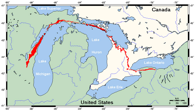
1/ GLACIERS CARVE OUT THE GREAT LAKES
During the last Ice Age, huge glaciers covered much of the land we now know as North America.
As these glaciers retreated, they scoured the land, carving out deep basins that would be filled with melted glacier ice to become the Great Lakes; Lake Superior, Lake Michigan, Lake Huron, Lake Erie and Lake Ontario.
2/ FLOWING WATER CARVES OUT THE NIAGARA RIVER
Two of these great lakes (Lake Erie to the south at a higher elevation and Lake Ontario to the north at a lower elevation) were connected by a river when massive amounts of water flowed from Lake Erie toward Lake Ontario, creating the Niagara River. This river followed a path over a natural “ledge” of hard rock.
3/ UNEQUAL LAND EROSION CREATES THE NIAGARA ESCARPMENT
The Niagara escarpment is a massive, 725-km-long crescent-shaped ridge of limestone and dolostone cliffs running from Lake Ontario to Manitoulin Island. The escarpment developed over millions of years as the softer and harder rock layers eroded at different rates.
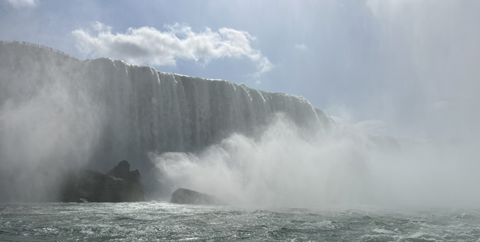
4/ WATER PLUNGED OVER THE ENSUING CLIFF
Thanks to its fancy new cliff, the Niagara River didn’t just flow between the 2 great lakes, it now suddenly plunged down, giving birth to a new waterfall.
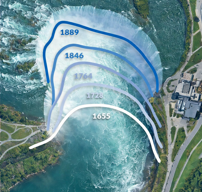
5/ THE FALLS CREPT BACK TO WHERE WE SEE IT TODAY
Over thousands of years, thanks in part to annual freezing and thawing of the Niagara River, the falls carved its way back around 7 miles / 11 kilometers from where modern day Queenston / Lewiston is now all the way back to where it is seen today.
WHEN WILL NIAGARA FALLS END?
Historically, erosion rates were as fast as 3 to 6 feet (1–2 meters) per year.
Today though, thanks in large part to modern water diversion for hydroelectric power, Niagara Falls recedes at a rate of approximately 1 foot per year, which still makes it one of the fastest receding Falls in the world.
For recent historical context, in 1678 the falls fell approximately where terrapin point on the US side of the border is now.
At this current pace, the Falls should recede the remaining 15 kilometers between its current position and Lake Erie in 50,000 years, when it will cease to exist and become a series of rapids, similar to what you can see during a White Water Walk.
So, get here and experience Niagara Falls for yourself before it’s too late! ;)
Walk Niagara Tours offers all-inclusive walking tours of Niagara Falls. Our tour guides lead groups 7 days a week between April and November.
Dan is a Niagara Falls tour guide with over 40 years of experience guiding visitors through
Niagara Falls Ontario, Canada. Known for his engaging storytelling and deep knowledge of
Niagara’s history and hidden gems. Dan is a licenced tour guide with Niagara Parks and has
helped thousands of travelers experience the falls beyond the postcard view.
Learn more about our tour guides here. Interested in booking a tour? Click here.
Learn more about our tour guides here. Interested in booking a tour? Click here.